Geospatial Services
Leading the Digital Transformation with GIS and Geospatial Data Expertise
In today’s fast-paced digital landscape, businesses are constantly seeking innovative solutions to stay ahead of the curve and drive meaningful change. At the forefront of this digital transformation is Microskill Technologies, a pioneering company specializing in Geographic Information Systems (GIS) and geospatial data. With a commitment to excellence and a passion for innovation, Microskill Technologies is revolutionizing industries and reshaping the way organizations leverage spatial data to achieve their goals.
GIS technology has emerged as a powerful tool for decision-making, enabling organizations to visualize, analyze, and interpret location-based data in unprecedented ways. From urban planning and environmental management to logistics optimization and disaster response, the applications of GIS are virtually limitless. Recognizing the immense potential of GIS to drive digital transformation, Microskill Technologies has positioned itself as a leader in the field, offering a comprehensive suite of services tailored to the unique needs of each client.
At the heart of Microskill Technologies’ success is its team of dedicated professionals who possess a deep understanding of GIS principles, advanced spatial analysis techniques, and cutting-edge geospatial technologies. With years of experience and a proven track record of delivering results, the team at Microskill Technologies is equipped to tackle even the most complex challenges and deliver solutions that exceed client expectations.
OUR BUSINESS

Microskill Technologies boasts a robust team of experienced Geospatial Specialists dedicated to ensuring the accurate and swift processing of GIS Projects. Our team excels in various GIS activities like resource mapping, data conversion, remote sensing, utility mapping, photogrammetry, and LIDAR data processing.
We swiftly gather and comprehend project requirements and processes, ensuring expedited project initiation. Coupled with our rigorous quality assurance process and the cost-effectiveness of outsourcing to India, we deliver one of the industry’s top-notch geographical and GIS-related services to our clients.
Remote Sensing
- Agricultural mapping
- Crop Monitoring & Assessment/Damage Assessment
- Creation of Topographic Databases
- Land Use and Land Cover Classification
- Forest Mapping: Canopy Cover Analysis in Forest Area and Vegetation Index (VI)
- Water Resource Management/Watershed Management


Photogrammetry
- Aero-Triangulation
- DTM / DEM / Digital Surface Model
- Orthophoto Generation
- 3D Vector Mapping and Planimetric Mapping
- 2D Vector Mapping from Orthophotos
Orthophoto Generation
Microskill Technologies specializes in producing high-resolution orthophoto imagery. Orthophotos are aerial photographs or satellite images that have been geometrically corrected, or ortho-rectified, to ensure uniform scale throughout the image. By rectifying the image with terrain data, we correct for terrain relief, camera tilt, and orientation, eliminating lean and distortion. We mosaic adjoining images through overlap areas using seam lines to create a seamless and color-balanced image in terms of both geometry and radiometry features. Orthophotos serve as maps of specific scales, aiding in various applications.

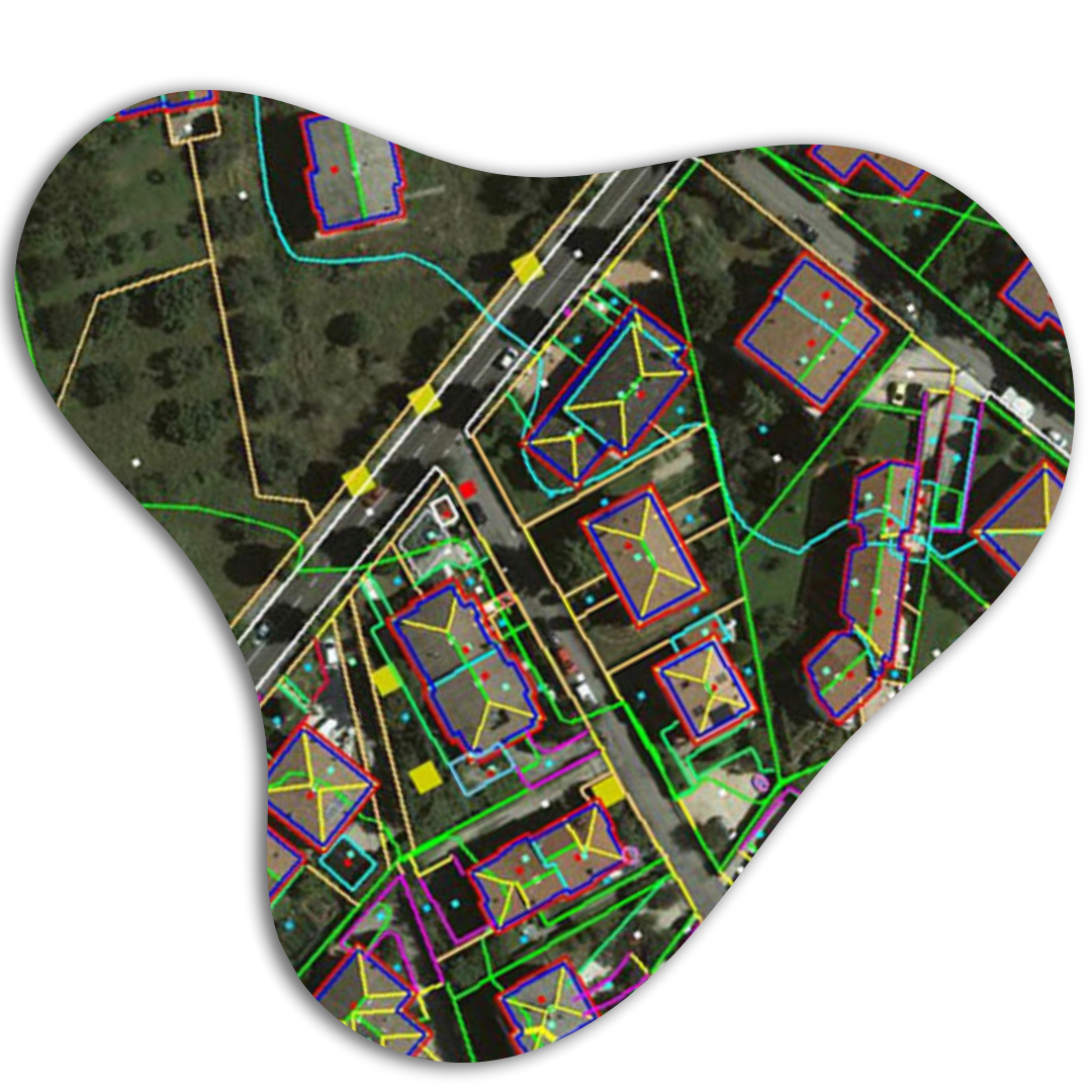
3D Vector Mapping / Planimetric mapping
Microskill Technologies specializes in 3D Planimetric/Topographic mapping, which accurately represents earth surface features with height elevation from the datum as Point/Symbol/Nodes, line/Polylines, and Polygon/region data. This comprehensive data enables users to conduct various analyses and make informed decisions tailored to their specific needs and applications. Our mapping services cover a wide range of features including building outlines, roads, rivers, vegetation, utility poles, and more, providing detailed insights for effective decision-making in diverse industries and sectors.
DTM / DEM / DSM (Digital Surface Model)
Microskill Technologies specializes in data collection for the creation of Digital Terrain Models (DTM), Digital Surface Models (DSM), and Digital City Models (DCM), among others. We utilize advanced techniques such as 3D data extraction from stereo pairs to generate accurate representations of elevation points, lines, and polygons. Our team employs a variety of methods including Automatic, Semi-automatic, and Manual terrain extraction to ensure precise results tailored to your specific requirements. These models are essential for various spatial analyses and algebra of the terrain, facilitating tasks such as cut and fill analysis, slope and aspect calculation, and hill shade analysis. With our expertise, we provide comprehensive solutions for terrain modeling to support informed decision-making in diverse industries and applications.

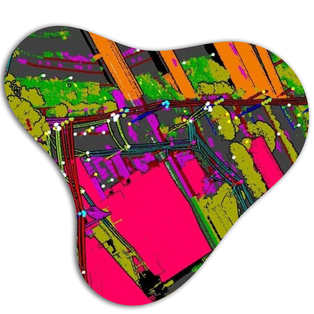
LiDAR SERVICES
Microskill Technologies specializes in LiDAR (Light Detection and Ranging), a remote sensing method for precise measurement of distances on the Earth’s surface. Our advanced technology enables mapping professionals to analyze natural and man-made features with unparalleled accuracy. LiDAR is utilized across various land management services including forestry, agriculture, watershed management, and geomorphological mapping. Additionally, it plays a crucial role in preserving man-made assets such as electrical and highway infrastructure. With Microskill Technologies, clients benefit from cutting-edge LiDAR solutions tailored to their specific needs, ensuring efficient and accurate data collection for informed decision-making.
Our LiDAR Services includes
- Bare Earth Extraction (DEM/DTM)
- Hydro flattened Break line & Contour
- Advanced Classification
- Powerline Corridor Mapping
- Planimetric Asset Mapping & Modelling
GIS Services
Microskill Technologies boasts a dedicated team of professionals with over a decade of experience in various domains of Geographic Information System (GIS). Committed to continuous improvement and innovation, our team ensures faster turnaround times and high-quality deliverables. We invest in our people, providing rigorous training to meet the growing needs of our clients. With Microskill Technologies, you can trust in our expertise and dedication to deliver exceptional GIS solutions tailored to your requirements.

GIS Services for Utility Mapping
GIS-centered utility mapping is crucial for modern infrastructure management, and Microskill Technologies excels in providing these solutions. With the expansion of various utility supply lines such as telecommunication, electrical, water supply, sewage, and gas pipelines, the need for efficient management without manual intervention is paramount. Geospatial data adds a spatial dimension to utility management, enabling better planning and decision-making. Trust Microskill Technologies to deliver accurate and reliable GIS-centered utility mapping services tailored to your infrastructure needs.
Telecommunication Network
- Telecommunication Network Creation/Updation, Optical Fiber Cable (OFC) Network Monitoring & Management
- Data handling and Data Migration
- Capacity Planning & Demand Forecasting
- Outage Management


Geo BIM Services
BIM and GIS integration is a pivotal process for modern construction projects, seamlessly blending BIM models with geospatial context layers. At Microskill Technologies, we excel in this integration, empowering designers with precise information for construction planning. Our Geo-BIM services offer geospatially positioned models integrated with Revit BIM models, allowing seamless visualization in GIS platforms. Trust us to enhance the efficiency of your design and construction processes through innovative spatial solutions.